Atmospheric river storm monitoring to improve forecasts
January 19, 2022
Between January 5 and April, “Hurricane Hunter” aircraft have been mobilized for a 13-week mission to collect data on atmospheric river storm events over the Pacific Ocean. Since these extreme storms provide up to half of the annual precipitation and a majority of the flooding in western states, the data collected is expected to improve forecasts of precipitation in the region.
Environmental monitoring sensors
The aircraft will drop dropsonde instruments over specialized transects of active atmospheric river events. The sensors transmit critical information about the vertical profile of parameters — water vapor, wind, and temperature — in fast-moving, low-altitude airstreams that form the atmospheric river.
This year, Air Force Reserve aircraft will also be equipped with airborne radio occultation capabilities. The occultation technique uses GPS signals to detect variations in atmospheric properties and provide critical moisture and temperature profiles in the larger environment surrounding the aircraft, complementing the dropsondes.
In addition 50 additional drifting buoys have been deployed in key locations throughout the northeast Pacific Ocean this season. Augmenting data collected by 48 buoys still active from previous seasons, the buoys measure and transmit sea-level pressure, water temperature and wave measurements. The data will fill a gap needed for numerical weather predictions and climate studies.
Weather forecasts
Meteorologists can detect forming atmospheric rivers as much as eight days in advance, but landfall forecasts can be hundreds of miles off-target.
CW3E Director and Scripps research meteorologist F. Martin Ralph said, “…the leading source of error in predicting when and where an atmospheric river will strike the U.S. West Coast and how much precipitation it will create is the position and structure of the atmospheric river itself offshore, prior to landfall.”
“Obtaining accurate measurements in and near the atmospheric river offshore using these aircraft and drifting ocean buoys has a significant impact on forecast accuracy. (It) not only fills in many data gaps over the Pacific Ocean for prediction, it improves scientific understanding that over time improves forecasts as well. These improvements are vital for water managers and public safety.”
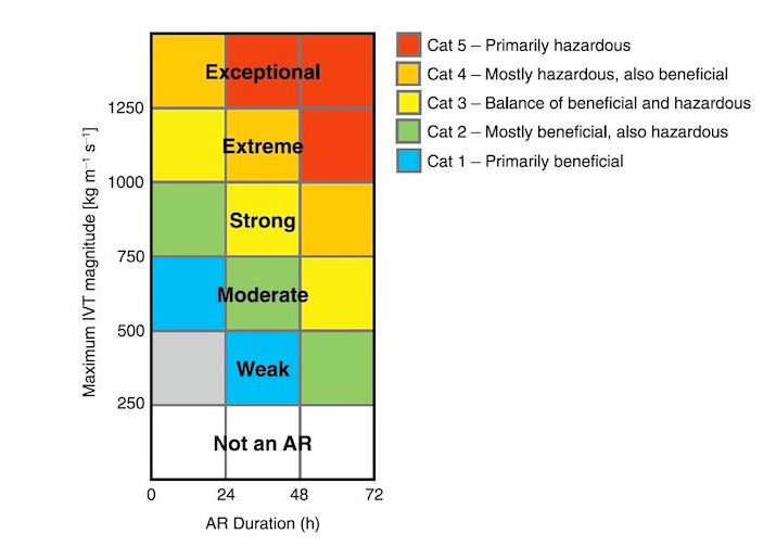
 More data can feed more accurate forecasts of storm intensity (as indicated by the one- to five-tier Atmospheric River scale) and more precise determinations of potential benefits or hazards.
On a practical level, the operationalization of data analytics can support decisions to release reservoirs or store water — both to prevent flooding and mitigate drought vulnerability in western states.
The infusion of data also provides more accurate analysis of upstream atmospheric conditions before potential high-impact weather events develop over the central and eastern parts of the country.
Led by the Center for Western Weather and Water Extremes (CW3E) at University of California San Diego’s Scripps Institution of Oceanography, the Atmospheric River Reconnaissance (AR Recon) program has observations dating back to 2016. The program is now included in the federal National Winter Season Operational Plan (NWSOP). This year, for the first time, the AR Recon Program will include real-time data collection and feedback that can instantly impact experiments being carried out with NOAA’s Global Forecast System.
KISTERS helps local, state and federal agencies and private organizations to more accurately measure rainfall events with ground-based sensors. In addition, modelers are able to integrate Global Forecast System raster data with their own monitoring network precipitation data, so high quality information supports operational and planning decisions.